
Know the Water First
Depth, exposure, shoreline and how far the boat can go — what owning on each of these lakes is actually like.
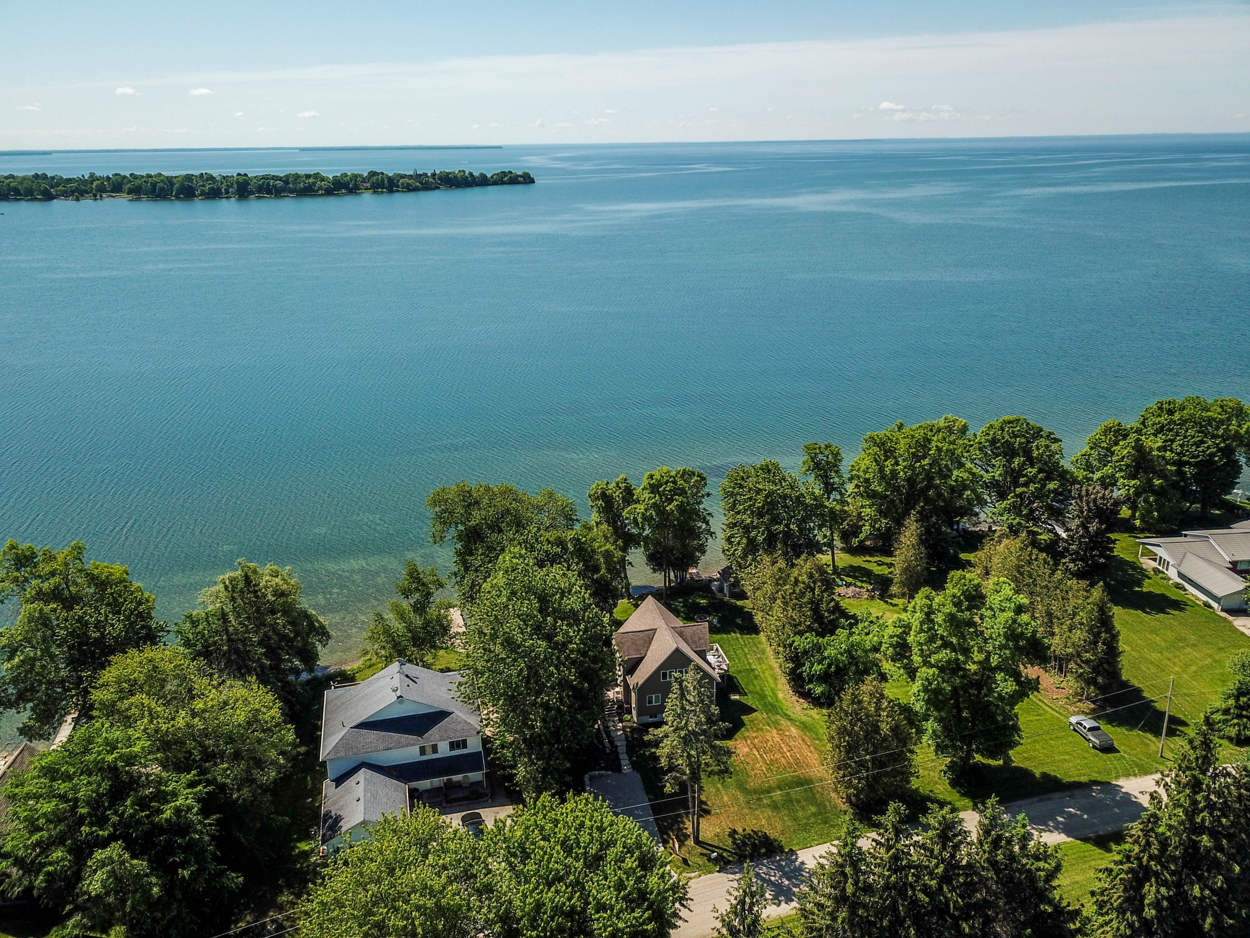
People buy a house and inherit a lake.
They fall for a dock, a sunset and a shoreline, and only afterwards discover what the water actually does — that the wind comes hard out of the northwest for three days at a stretch, that the bay is four feet deep for a hundred metres out, that the boat cannot get past a lock a mile downstream, or that the sun sets behind the trees rather than over the water.
None of that is visible in August at two in the afternoon, which is when almost every waterfront property in this region is shown.
So this section is about the water rather than the houses. What each lake is, how deep and how exposed, where it connects to and where it does not, and what owning on it is actually like in November.
What changes from one lake to the next
The most useful thing to understand before you buy is how far the water goes.
Some of these lakes open onto the Trent–Severn. Simcoe, Couchiching, Balsam, Pigeon and Gloucester Pool are links in a 386-kilometre navigable chain running from Lake Ontario to Georgian Bay, and a boat on any of them can reach either end given time, lockage and the right dimensions. That range is part of what the frontage is worth.
Joseph, Rosseau and Muskoka connect to each other. Deep, cold and granite-bound, with no navigable route through to the Trent–Severn.
And a great many lakes here connect to nothing at all. Quieter water, no passing boats, and for a good number of buyers that is the whole appeal.
None of this makes one lake better than another. It changes what you are buying, and it changes what the frontage is worth.
| Lake | System | Size | Depth | Best suited to |
|---|---|---|---|---|
| Simcoe | Trent–Severn | 722 km² | 14 m average · 42 m max | Open-water boating, four-season fishing and GTA access |
| Couchiching | Trent–Severn | 45 km² | 12 m max | Smaller-water boating with Orillia convenience |
| Balsam | Trent–Severn | 48 km² | — | Family recreation, clean water and Trent–Severn cruising |
| Pigeon | Trent–Severn | 57 km² | 3.3 m average · 13.5 m max | Warm-water fishing, nature and Bobcaygeon access |
| Gloucester Pool | Trent–Severn | — | over 27 m | Rugged scenery and Big Chute / Georgian Bay adventure |
| Joseph | Muskoka | — | 93 m max | Deep clear water, privacy and prestige estates |
| Rosseau | Muskoka | 64 km² | 89 m max | Social Big Three living and connected boating |
| Muskoka | Muskoka | 120 km² | — | The widest choice of classic Muskoka settings |
Conditions vary by property, bay, exposure, access and municipality. Descriptions reflect typical buyer fit, not a lake-wide guarantee. A dash marks a figure we have not been able to source to a primary record.
Featured lakes on the Trent–Severn
All five are links in the same 386-kilometre navigable chain. Balsam, Pigeon and Gloucester Pool sit on it alongside Simcoe and Couchiching — and in our experience two of the three can offer better value, depending on shoreline, access and exposure.
Lake Simcoe
722 square kilometres — the fourth-largest lake lying wholly within Ontario, and by a wide margin the biggest water in this region. It is not, whatever you read, Ontario’s largest inland lake.
An early recorded name is Ouentironk, which Ontario sources translate as “beautiful water.” John Graves Simcoe renamed it in 1793 after his father, a Royal Navy captain — not, as almost everyone assumes, after himself.
Depth is the thing buyers get wrong. Simcoe averages about 14 metres, but Kempenfelt Bay drops to 42 metres — a glacial trench, and a different lake from the broad shallow water elsewhere.
And exposure decides value more than almost anything else here. Southern and eastern shorelines can be more exposed to onshore winds and storms. But fetch, bay shape, orientation and local shelter vary enormously from one lot to the next, so exposure is a property-by-property assessment rather than a shore-wide rule. It is also not a marketing distinction — it is the difference between a boathouse that survives a November gale and one that does not.
Between 2014 and 2022, estimated winter angling effort on Simcoe averaged about three and a half times the summer figure.
The shoreline communities are worth knowing by name. On the Oro-Medonte side: Shanty Bay, Hawkestone, Oro Station and Carthew Bay, running along the sheltered northwestern shore. Across the water in Ramara: Brechin, Bayshore Village and Lagoon City. And on the point between Simcoe and Couchiching, Eight Mile Point — one of the most private addresses on the lake, and one of the few places where you can watch the sun go down over open water from a shoreline that faces west.
A buyer who bought on Eight Mile Point described it in her own words, in a verified review: “a precious area giving us the privacy we desire and a community we appreciate.” Read the reviews →
Lake Couchiching
Forty-five square kilometres and nowhere deeper than about twelve metres — small, sheltered, and joined to Simcoe at the Atherley Narrows with no lock between them. Open water, both ways, any time. From the north end, Lock 42, the Couchiching Lock just downstream of Washago, starts the four-lock run to Georgian Bay: Couchiching, Swift Rapids, Big Chute and Port Severn.
The name is Ojibwe — Gojijiing, “at the place where it goes out,” a reference to how the water leaves the lake. That reading comes from Chippewas of Rama First Nation. The “lake of many winds” translation you will find on half the listings in Orillia is not supported by any source we could find.
And one widely accepted explanation traces Toronto’s name to this narrows. The Mohawk word Tkaronto — “where there are trees standing in the water” — described the fish weir stakes driven into the channel bed here, in use since about 3300 BC and carbon-dated in excess of five thousand years. French maps from the 1680s onward label Simcoe Lac de Taronto. The name travelled south with the fur route and stayed there. The weirs are a National Historic Site, sacred to the Huron-Wendat and the Anishinaabeg, and every boat that leaves Simcoe passes over them.
For a buyer, the shore decides the day. The Ramara side faces west and takes the sunset over open water. The Orillia side faces east and buys you a walkable town, services and the Port of Orillia instead.
Choosing between the two systems is the decision that shapes every other one. Arrange a private conversation
Balsam Lake
The summit of the Trent–Severn Waterway. 256.2 metres above sea level — the summit of the Trent–Severn, and the point from which water runs downhill in two directions at once: east through Rosedale toward Lake Ontario, west through the Kirkfield Lift Lock toward Georgian Bay.
Forty-eight square kilometres, fed by the Gull River out of the highlands, draining east through the Rosedale River to Cameron Lake and west through the engineered cut at Kirkfield. Kawartha Conservation’s monitoring records nearshore water quality here as generally excellent.
Balsam Lake Provincial Park is roughly 449 hectares on the northwest shore, meaning a substantial stretch of this lake will never be built on — a permanent constraint on supply.
Coboconk sits at the north end where the Gull comes in. J.E.H. MacDonald of the Group of Seven painted this river.
Pigeon Lake
Fifty-seven square kilometres and the third largest of the thirteen major Kawartha lakes on Kawartha Conservation’s count, and shallow: 3.3 metres on average, 13.5 at its deepest. Limestone basin rather than granite, which means warm water, productive aquatic vegetation through many nearshore areas, and a completely different summer from Muskoka.
Bobcaygeon’s Lock 32, at the narrows between Pigeon and Sturgeon, was the first lock built on the entire Trent–Severn, in 1832–33. The waterway grew outward from here in both directions over the following eighty years.
And Pigeon carries two of the region’s largest permanently protected natural areas. Big Island — properly Big (Boyd/Chiminis) Island — is 1,148 acres and the largest undeveloped island in the Kawarthas; it was donated to the Kawartha Land Trust in two stages, in 2015 and 2022. The 1,412-acre Hammer Family Nature Preserve on the east shore was protected at the end of 2023, purchased with support from Ontario’s Greenlands Conservation Partnership. That is roughly 2,560 acres on one lake permanently protected from development by the Kawartha Land Trust.
Manoomin — wild rice — grows in the southern end, harvested under treaty right, with a protection zone established by Parks Canada.
The word Kawartha comes from Martha Whetung of Curve Lake First Nation, who was asked for a name by a tourism promotion party out of Bobcaygeon. She proposed Ka Wasa — “water that shines.” It had already been corrupted to Kawatha before the party got home, and the “r” was added later by a Buffalo marketing agency. The cheerier “bright waters and happy lands” came later still. This account is Maryboro Lodge, the Fenelon Falls Museum.
Gloucester Pool
The last water before Georgian Bay, and the most dramatic of the eight. Over 27 metres deep on Ontario’s bathymetric mapping, granite slopes running straight into it, mixed pine, oak and maple to the waterline. It drains through Little Lake at Port Severn and out.
One thing to know before you look here: Gloucester Pool straddles a municipal boundary. Part of it lies in the Township of Severn, Simcoe County, and part in the Township of Georgian Bay, District of Muskoka. Which side a property sits on determines its taxes, its building permits and its planning authority, so confirm the municipality before anything else.
At its edge is Big Chute, which is not a lock at all but a marine railway: a cable-drawn carriage that lifts boats out of the water and carries them over a hill on rails, raising them 17.7 metres — 58 feet — in the process. It is the only one of its kind still in use in North America, and it was deliberately kept rather than replaced, because a gap in the water stops sea lamprey reaching everything upstream.
Downstream, Lock 45 at Port Severn is the smallest chamber on the entire system — and at about 25.5 by 7 metres — 84 by 23 feet — it sets the maximum length and beam of any vessel that can cross the waterway end to end. Height is capped separately, by a minimum bridge clearance of 6.1 metres, and weight by the 90-tonne carriage at Big Chute.
The Muskoka Big Three
Joseph, Rosseau and Muskoka connect to each other, with no navigable route through to the Trent–Severn. Deep, cold and granite-bound — which is the point rather than a limitation.
Lake Joseph
The deepest and the clearest of the Muskoka three, and both are measurable rather than claimed. Maximum depth 93 metres against Rosseau’s 89. Water clarity 6.7 metres on the Secchi disc against Rosseau’s 5.4, both from the Ontario MNR lake fact sheets. Provincial data, not brochure copy. Oligotrophic, cold and granite-bound, and one of the Parry Sound district’s designated natural lake trout lakes.
It crosses a district boundary. Ontario MNR places Lake Joseph in both Medora and Humphrey townships: the south and east shores in the Township of Muskoka Lakes, District of Muskoka, and the west shore and north end in Seguin Township, Parry Sound District. Lake Rosseau straddles the same line — two districts, two townships, two planning regimes, one lake. Almost nobody selling here mentions it, and it matters for anything involving permits.
Joseph and Rosseau sit at the same elevation — 225 metres on the Ontario MNR fact sheets. That is why Port Sandfield has no lock. The cut there is not a natural narrows at all: it was cut through a sand isthmus and named for John Sandfield Macdonald, Ontario’s first premier. The Dictionary of Canadian Biography records the canal as commissioned by 1869 and complete by 1872. A single swing bridge is the pinch point for traffic between both lakes.
Sherwood Inn dates its opening on this shore to 1939.
A note on the marketing. “Millionaires Row” and “Billionaires’ Row” are marketing terms with no defined geography behind them. Lake Joseph does not need either. On the Ontario MNR lake fact sheets it is the deepest and the clearest of the Muskoka three, and those are measurements.
Lake Rosseau
6,390 hectares, 89 metres at its deepest, and the same 225-metre elevation as Joseph — which is why the two are joined by an open cut rather than a lock, and why a boat moves between them without stopping.
Rosseau is the social lake of the three. Windermere House’s resort history on this shore dates to 1870; the present hotel was reconstructed in 1997 after the 1996 fire. The Rosseau General Store at the north end is still trading, established in 1874 by the store’s own account. The Port Carling locks, begun in 1869 and finished in 1871, opened steamship traffic through to Rosseau and effectively invented the Muskoka that people picture.
Where Joseph is deep, cold and comparatively austere, Rosseau is broader and more settled, with a longer continuous history of the same families in the same bays. For a buyer, that is the trade: Joseph for water and privacy, Rosseau for a community that already exists.
Lake Muskoka
The largest of the three at 120 square kilometres, and lower than Joseph and Rosseau — which is the entire reason the Port Carling locks exist. Everything upstream is one level; Muskoka is a step down.
Its outflow is at Bala into the Moon River, which divides into the Moon and Musquash channels downstream, both running west to Georgian Bay — not navigable through, which is what keeps the Muskoka system closed.
The Muskoka Lakes Association was founded here in 1894 — and describes itself as Canada’s oldest cottage association.
And L.M. Montgomery set The Blue Castle — her only book without a Prince Edward Island setting — on this water, on the fictional Lake Mistawis, after her stay at Bala in 1922.
Muskoka has the widest range of the three: genuine estate shoreline at Beaumaris, working village frontage at Bala, and everything between.
Weighing Joseph, Rosseau and Muskoka against one another? Arrange a private conversation
Before you buy on the water
Every question that decides the value of a waterfront property is a question about the water.
Which way does the shore face, and where does the sun actually set from the dock. How deep is it at the end of that dock in September, not May. What is the fetch, and what does the wind do to this bay in a November blow. Is the frontage clean sand, weed bed or granite shelf. What is the shoreline structure regulation on this particular lake, and can the boathouse in the photographs be replaced if it burns. Where can the boat actually go, and what is the first lock that stops it.
None of it is answerable from a listing, and all of it is answerable from the dock.
If you are looking at waterfront anywhere in Lake Country, start there.
Looking at land instead? The estate acreage, farms and heritage villages behind these shorelines are next door. Explore the Communities →
Written by Bill Jackson, Sales Representative, The Lake Country Real Estate Team, brokered by eXp Realty. CLHMS® — Certified Luxury Home Marketing Specialist · GUILD™ — Institute for Luxury Home Marketing.
Bill lives on Lake Simcoe, in Ramara, and has worked waterfront and estate property across Simcoe County, Muskoka, Parry Sound, Kawartha Lakes and Haliburton for over twenty years. More about Bill · Verified client reviews
Last reviewed August 2026. Lake depths, elevations and designations cited on this page are drawn from Ontario MNR lake fact sheets, Parks Canada and municipal sources.